

Batur Mount is an active volcano in he district of Kintamani, Bangli regency, Bali, Indonesia. Located in the northwest of Agung Mount, the mountain has a caldera measuring 13.8 x 10 km and is one of the largest and most beautiful in the world (van Bemmelen, 1949). Caldera ridge height ranges from 1267 m - 2152 m (peak G. Abang). Inside the caldera, I formed a circular caldera II with diameters of approximately 7 km. Basic caldera II is located between 120-300 m lower than the terrace of Kintamani (basic Caldera I). Inside the caldera there are crescent-shaped lake which occupies the southeastern part of about 7.5 km in length, maximum width 2.5 km, circumference about 22 km and breadth of about 16 km2, which is called Batur Lake is the largest lake in Bali. Batur Mount Caldera eruption is expected to form because of two huge, 29,300 and 20,150 years ago. Batur Mount consists of three volcanic cone with each of the crater, I Batur, Batur Batur II and III.
2. Ayung River

Ayung River is a river that rises near Penulisan, on the rim of the Batur crater, and flows almost due south, passing west of Ubud in a deep gorge (overlooked by several five-star resorts) and emptying into the Badung Strait just north of Sanur. The Ayung is Bali's longest river, measuring approximately 75 kilometers from source to mouth. It's popular with white-water rafters, but its rapids do not exceed Level III. The Ayung has a relatively small drainage area, as most of its tributaries run in parallel valleys.
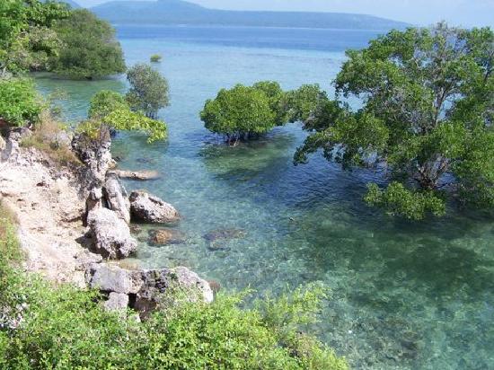
3. Coral reefs Tulamben Beach
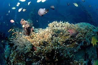
Tulamben Area Kubu village, is a very interesting place in Bali, especially for those who love diving. Geographically administrative, Tulamben is located in Karang Asem regency, and is about 100 km from Denpasar commonly taken within 3 hours drive by using 4-wheel vehicle.
In Tulamben own, the most famous diving site is the Cargo Ship Wreck or USS Liberty Shipwreck that sank only 30 meters from the rocky shoreline village of Tulamben. The depth of the wreck (Ship Wreck) was started from a depth of 5-35 meters.
This wreck is inhabited by thousands of marine species of fish, shrimp, sea slugs (nudibranchs), crabs, and colorful coral. Even some large animals such as shark, Whale Shark, and Sunfish / Mola mola is often encountered in this area. It is highly preferred by underwater photographers from around the world. Want motret wide angle or macro, are all available in Tulamben.
In addition to Liberty Shipwreck, walk 100m to the east as far as can already be found in dive site that has Drop off cliff underwater contours (wall) with a pretty good vizibility.
When the sand in this bay Tulamben black rocky, but unique to within 150 meters to the east of the drop off dive sites are found with white sand. Sites include Allamanda and stone kelebit. For this diareal dive we usually use a traditional Balinese boat is often called "boats".
4. Agung mountain

Agung Mount is the highest mountain on the island of Bali with a height of 3142 masl. The mountain is located in the district of Rendang, Karangasem regency - Bali.
Agung Gunung is a volcano [[stratovolcano]], this mountain has a very large crater is very deep and sometimes smoke and water vapor. Pura Besakih From this mountain with a conical taper seems perfect, but the actual peak of this mountain elongated and ends in a circular craters and wide.
From the top of Agung Mount we can see the peak of Mount Rinjani in Lombok island, although both mountains covered with clouds because both peaks are above the clouds.
Balinese Hindu community believe that Agung Mount is the place bersemayamnya the gods, and also society believe that these mountains there is the palace of the gods. Therefore, the Balinese community to make this place as a place that purified Kramat.
5. Gitgit Waterfall
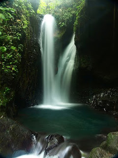
Waterfall is the largest and highest waterfall in Bali, located in the Village District Gitgit Sukasada. From the Singaraja city located 11 km to the south toward the Village Pancasari and Bedugul. Waterfall-altitude ± 35 feet is very beautiful and has a beautiful panorama and are in a temperate environment sejuk.Turun walking distance after passing the parking Gitgit, some local youths organized by the local traditional village offers tours take the tourists toward the water This beautiful waterfall. In addition to the pounding sound of the waterfall and chirping birds, a paddy field, clove and coffee plantations / as well as bamboo plants along the road to the waterfall presents a peaceful and natural atmosphere.
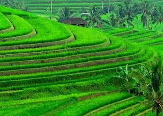
6. Jatiluwih Terracing
7. West Bali National Park
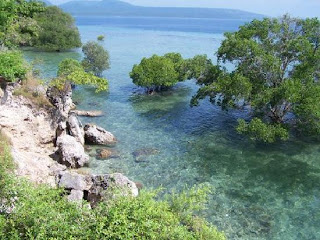
West Bali National Park is located in the western part of the island of Bali in Indonesia. This national park has a 77.000 hectare area, which covers approximately 10% of the land area of the island of Bali.
West Bali National Park consists of various forest habitats and savanah. In the middle of the park is dominated by the remains of four volcanoes of the Pleistocene, with mountain Patas as the highest point in this place.
About 160 species of animals and plants are protected in this national park. The animals like bull, deer, monkeys, bats and various birds. West Bali National Park is the last place to find the only one endangered endemic Bali, Bali Starling in their natural habitat.
2. Ayung River

Ayung River is a river that rises near Penulisan, on the rim of the Batur crater, and flows almost due south, passing west of Ubud in a deep gorge (overlooked by several five-star resorts) and emptying into the Badung Strait just north of Sanur. The Ayung is Bali's longest river, measuring approximately 75 kilometers from source to mouth. It's popular with white-water rafters, but its rapids do not exceed Level III. The Ayung has a relatively small drainage area, as most of its tributaries run in parallel valleys.
3. Coral reefs Tulamben Beach

Tulamben Area Kubu village, is a very interesting place in Bali, especially for those who love diving. Geographically administrative, Tulamben is located in Karang Asem regency, and is about 100 km from Denpasar commonly taken within 3 hours drive by using 4-wheel vehicle.
In Tulamben own, the most famous diving site is the Cargo Ship Wreck or USS Liberty Shipwreck that sank only 30 meters from the rocky shoreline village of Tulamben. The depth of the wreck (Ship Wreck) was started from a depth of 5-35 meters.
This wreck is inhabited by thousands of marine species of fish, shrimp, sea slugs (nudibranchs), crabs, and colorful coral. Even some large animals such as shark, Whale Shark, and Sunfish / Mola mola is often encountered in this area. It is highly preferred by underwater photographers from around the world. Want motret wide angle or macro, are all available in Tulamben.
In addition to Liberty Shipwreck, walk 100m to the east as far as can already be found in dive site that has Drop off cliff underwater contours (wall) with a pretty good vizibility.
When the sand in this bay Tulamben black rocky, but unique to within 150 meters to the east of the drop off dive sites are found with white sand. Sites include Allamanda and stone kelebit. For this diareal dive we usually use a traditional Balinese boat is often called "boats".
4. Agung mountain

Agung Mount is the highest mountain on the island of Bali with a height of 3142 masl. The mountain is located in the district of Rendang, Karangasem regency - Bali.
Agung Gunung is a volcano [[stratovolcano]], this mountain has a very large crater is very deep and sometimes smoke and water vapor. Pura Besakih From this mountain with a conical taper seems perfect, but the actual peak of this mountain elongated and ends in a circular craters and wide.
From the top of Agung Mount we can see the peak of Mount Rinjani in Lombok island, although both mountains covered with clouds because both peaks are above the clouds.
Balinese Hindu community believe that Agung Mount is the place bersemayamnya the gods, and also society believe that these mountains there is the palace of the gods. Therefore, the Balinese community to make this place as a place that purified Kramat.
5. Gitgit Waterfall

Waterfall is the largest and highest waterfall in Bali, located in the Village District Gitgit Sukasada. From the Singaraja city located 11 km to the south toward the Village Pancasari and Bedugul. Waterfall-altitude ± 35 feet is very beautiful and has a beautiful panorama and are in a temperate environment sejuk.Turun walking distance after passing the parking Gitgit, some local youths organized by the local traditional village offers tours take the tourists toward the water This beautiful waterfall. In addition to the pounding sound of the waterfall and chirping birds, a paddy field, clove and coffee plantations / as well as bamboo plants along the road to the waterfall presents a peaceful and natural atmosphere.
6. Jatiluwih Terracing

The amazing rice terraces of Jatiluwih in northern Bali reminds that humans’ ability to transform landscapes long predates bulldozers and cranes. Rice is the staple crop of Indonesia. In Bali, fertile volcanic soil, plentiful rain and genetically modified strains of rice mean that three harvests are possible in one year. Apparently, the modern strains of rice aren’t as tasty as the old, slower-growing varieties. Not that I would be able to tell the difference.
7. West Bali National Park
West Bali National Park is located in the western part of the island of Bali in Indonesia. This national park has a 77.000 hectare area, which covers approximately 10% of the land area of the island of Bali.
West Bali National Park consists of various forest habitats and savanah. In the middle of the park is dominated by the remains of four volcanoes of the Pleistocene, with mountain Patas as the highest point in this place.
About 160 species of animals and plants are protected in this national park. The animals like bull, deer, monkeys, bats and various birds. West Bali National Park is the last place to find the only one endangered endemic Bali, Bali Starling in their natural habitat.